Monday, April 9, 2012

Blast from the Past
We are starting Telecommunicator Week off with a little blast from our past! Check our these pictures from past 9-1-1 centers we've operated in!
 |
| Our first home in the basement of the Cumberland County Courthouse! |
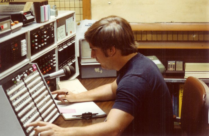 |
| Dispatcher in action in the old 9-1-1 center |
 |
| Couthouse basement |
 |
| Old call taker position |
 |
| Basement of the prison |
Monday, April 2, 2012
Cumberland County Telecommunicator Week
April 2, 2012
FOR IMMEDIATE RELEASE
CONTACT: Megan Silverstrim, Cumberland County
717.218.2913
Cumberland County Commissioners Proclaim Telecommunicator Week
Cumberland County, Pennsylvania– The Cumberland County Board of Commissioners proclaimed April 9th-13th as Cumberland County Telecommunicator Week during their regular meeting today. The purpose of this week is to recognize the efforts of the 38 Department of Public Safety 9-1-1 dispatchers who answer the calls for help from residents and visitors in Cumberland County.
Telecommunicator Week, a nationwide initiative, was first established in 1991, with the intent of bringing to light the hard work and accomplishments of our nation’s public safety dispatchers. In 2011, Cumberland County 9-1-1 dispatchers answered 346,536 incoming calls. Dispatchers are not only a life line for those calling the center for help, but also for the emergency services personnel who respond. Whether investigating a crime, fighting a fire, caring for a patient, 9-1-1 dispatchers are there for the first responders who need more resources or may find themselves in danger and in need of help themselves.
Cumberland County dispatchers are responsible for the answer of 9-1-1 calls and dispatch of emergency services personnel Cumberland County as well as Fulton County. For more information on the Department of Public Safety and the 9-1-1 Communication Center visit www.ccpa.net.
# # #
Friday, March 30, 2012
Thursday, March 29, 2012
Storm Chaser
At first glance, it’s a little rough around the edges – literally. But there is something charming about the 14,000-pound tank as it sits along the downtown street in Harrisburg, PA.
Children clamor up the sides like it’s a jungle gym. “Can we get in,” one yells. Designer, film maker, and storm chaser Sean Casey smiles, a twinkle in his eye says yes, but an employee from the science center steps up and says “sorry, not unless you’re over eight (years old).”
The little boy’s smile deflates like a popped balloon, but his older brother says “I’m eleven!” The science center employee hands a parent a legal consent form to complete.
Recently made famous as a central figure in Discovery Channel’s now-cancelled show “Storm Chasers”, film maker and storm chaser Sean Casey is in Harrisburg promoting his IMAX movie, “Tornado Alley 3D”. He brought along his custom made Tornado Intercept Vehicle – or TIV. Being the second incarnation, it’s affectionately called TIV 2.
 |
| Photo by: Caroline Anschutz |
TIV 2 is built on the chassis of a Dodge Ram 3500. The vehicle sports two-inch thick armor plating and bullet proof glass. Four “skirts” on each side drop down to block tornadic winds from getting under the vehicle and rolling it over. In fact, they allow the air to push over the roof of the vehicle creating extra down force. If the air-blocking skirts aren’t enough, two hydraulic spikes on each side of TIV 2 can extend up to 40 inches into the ground, anchoring TIV 2 in place.
After speaking about the spikes, Casey cracks a boyish grin and reaches into the back of TIV 2 and produces an elongated box. “My next set of spikes,” he says.
 |
| Photo by: Caroline Anschutz |
TIV 2 runs on a 6.7-liter, 625-horsepower Cummins turbo diesel engine and Casey and Cummins just entered into a partnership to upgrade the TIV and launch a new media venture. While details of the partnership haven’t been released, Casey did acknowledge he is working with the diesel manufacturer on much-needed upgrades.
I was lucky enough to ride in TIV 2 with Casey at the wheel. It's remarkably quiet, considering its construction and the shotgun seat is pretty comfortable.
With more than 100,000 miles on it, TIV 2 is showing some wear. “We average about 30,000 miles a season,” Casey remarked. “A (storm chasing) season runs about eight to ten weeks.”
 |
| Photo by: Caroline Anschutz |
When asked about a sequel, Casey says they’ll be out filming again later in the year. They just procured funding from the National Science Foundation. “It’s going to be a good year,” Casey remarked. “The moisture is there and the jet steam (is supportive).”
Casey added, “I’ve got the (storm chasing) bug.”
By Guest Blogger Jon Anschutz is a 9-1-1 dispatcher with DPS as well as the Emergency Management Coordinator for Monroe Township. Jon also guest blogs on weather for www.agweb.com!
Tuesday, March 27, 2012
Angry Sky
May 26, 2011 – 7:10 PM
Central Cumberland County is in chaos. A severe thunderstorm is plowing across the county. Several minutes ago, it struck the Carlisle area, leaving behind a large damage path of toppled trees, downed power lines, and localized flash flooding.
As the storm moves to the east-northeast, a small tornado touches down somewhere in the vicinity of Route 114 and Willow Mill Park in Silver Spring Township. The tornado remains on the ground for the next four minutes, tearing down more than 100 trees and destroying an outbuilding before dissipating somewhere in the area of Sears Run and Wertzville RD in Hampden Township. No lives are lost or injuries reported. The thunderstorm continues across Cumberland County leaving more wind damage behind. Despite the damage, the county dodged a bullet.
Late May's tornadoes are nothing new to Pennsylvania. Two large outbreaks occurred on May 31st in previous years, one in 1998 and a larger, more deadly one nearly three decades ago in 1985.
My family was affected by the 1985 tornado outbreak. This is my family's story of that day and is one of thousands of stories from those who experienced nature's wrath.
As most Pennsylvania's slept during the early morning hours of Friday, May 31, 1985, a warm front surged north across the Commonwealth. Warm, moist air streamed in behind it. By the afternoon, many weather recording stations were reporting temperatures well into the 80's.
Sometime during the sunny morning, my family piled into our Ford station wagon for a day trip to Kinzua Dam state park, near the Pennsylvania/New York border. While we were there, we did the typical activities you would associate with a visit to a state park: hiking, sight seeing, and picnicking. I remember the heat that day – it was stifling.
My next memory from that day was the point where we decided to leave – the point where Mother Nature was beginning to throw out hints at what was in store.
By mid-afternoon, a strong cold front was plowing east from the Midwest. Tornadoes were already developing across the Canadian Provence of Ontario. Five tornadoes ranging in intensity from F3 to F4 ripped across Ontario that day. The first thunderstorms began to form over Ohio by 4PM and weather officials in the Northeast knew a major tornado outbreak was becoming nearly inevitable.
An Angry Sky
My father tells me I called it “an angry sky” and as I remember that day, I suppose that is an accurate statement – at least coming from a five-year-old boy. I certainly didn't know what I was looking at, but it must have unsettled me.
I can remember the clouds. They appeared so low you could reach up and grab them. As the clouds thickened, the color of the sky changed from a dreary gray to a yellowish-green hue. The clouds swirled and rolled and the breeze was warm; so warm it took your breath away. I remember the air felt heavy, adding to the unsettling environment that was quickly enveloping us.
This was the first clue the bad weather was coming, although I'm told there was no indication that tornadoes were a possibility. It was probably just an afternoon thunderstorm, common across Pennsylvania on hot and hazy days. We elected to cut our day short and return home. A couple of hours after we left, a large F4 tornado would tear across the Allegheny National Forest, 4 miles south of the dam. The tornado eventually struck the town of Kane, just before sunset at approximately 8:15 PM. Three people were killed.
A Town Wiped from the Map
About 50 miles south of Erie, PA is the small farming community of Atlantic, the place my grandmother called home. Situated at a rural cross roads, the town is bisected by a railroad and surrounded by working farms of various sizes.
At the center of town lies the intersection of the two two roads, one running north-south and the other east-west. From those two main roads, perfectly straight rural roads form a grid, more reminiscent of a Midwestern town than one in Pennsylvania. A large Amish and Mennonite community resides in the area and it isn't uncommon to have more horse-and-buggy combinations traveling up and down the roads than cars.
A large feed mill sits along the east-west road along the railroad. It's tall grain elevator and silos adorned with the Purina red and white checkered flag tower over the village. For a while it was the tallest structure around, until the 300 foot high AT&T transmission tower was built on the eastern outskirts of town.
Like many others across the western half of the state, the residents of Atlantic enjoyed an early taste of summer. Temperatures rose into the mid-80s. By 5:00PM, the National Weather Service office had issued a tornado watch, advising residents of the possibility of tornadoes. Minutes later that danger would become realized.
At 5:20 PM, a tornado was spotted several miles west of Atlantic, just outside the town of Jamestown. At the point of touchdown, the tornado is estimated to have been an F2 – with winds topping out at 157 MPH. Atlantic had only moments to prepare. At the same time the tornado was spotted, meteorologists in Erie, PA spotted the “hook echo” signature on radar – at that time it was the only way meteorologists had of remotely spotting tornadoes. A “hook echo” shows rain and debris swirling around the tornado's center of circulation, giving it the appearance of a fish hook on radar. A tornado warning was broadcast, but many homes did not have the necessary weather radios to receive such a warning. Televisions would be the only other way to receive warnings – until the storm cut the power.
Minutes prior to the tornado, Atlantic residents recalled hail the size of golf balls falling around them. Then the tornado appeared. To the west of Atlantic was a long ridge that ran from north to south. Residents looking to the west likely never saw the tornado coming until it topped the ridge. At that point, only seconds remained to react.
By the time to twister crested the ridge, it swelled to an F4 with estimated wind speeds up to 260 MPH. Some residents were lucky enough to get to shelter, others were not. In one home alone, five people were killed. Others died in a mobile home park, unable to get to adequate shelter. The tornado was over in minutes, as it exited the town it toppled the red and white striped 300 foot communications tower which was built to withstand 200 MPH winds.
My grandmother lived across the street from the feed mill. Just down the hill from the railroad crossing. Fortunately, she was not home at the time; rather, since it was the last day of school, she was attending a graduation party a few miles from town.
I don't remember how we found out about the Atlantic tornado. But I remember my mother was talking on the phone and crying. Such a memory sticks with a five-year old.
My mother left immediately for Atlantic. She was not allowed in and resorted to leaving the car and walking to the property where she grew up. I never saw the house after the tornado, we kids weren't taken to Atlantic until my grandmother received her new double-wide home. I'm told the tornado didn't directly hit her house, but it managed to throw a tree through the middle of it. The house crashed down around the tree. I'm also told my the tree didn't come from my grandmother's property.
Several months later, my grandmother was contacted by a family in New York state. They found some of her canceled checks in the woods behind their house.
There were 23 confirmed tornadoes that touched down across Eastern Ohio, Southwestern NY, and Western and Central PA. Of the 23 tornadoes, 21 struck Pennsylvania. 9 of the 21 tornadoes were fatal and 8 were classified as violent, ranking F4 or F5 on the Fujita scale.
In Pennsylvania, 65 people were killed and more than $300 million in damage occurred. On tornado, which struck Wheatland, PA was classified at the top of the scale - F5 and is still believed to be the strongest tornado ever to strike the state.
The May 31, 1985 tornado outbreak remains the worst recorded in the history of the state.
Growing up, I studied tornadoes and weather as much as I could, reading books and watching documentaries. I applied to and was accepted by the University of Oklahoma to become a severe storms forecaster. However, in the end, I opted to stay in Pennsylvania. Instead, I eventually chose to develop a career in Emergency Management – I credit that terrible day for setting me on this path.
We often hear about such calamities in the Midwest – in that zone that stretches from Texas north to Kansas called Tornado Alley. But here is evidence that it can happen here in Pennsylvania and by all accounts, I believe one day it will happen again.
In the 21st century, we're a more storm ready community. The 1985 tornado outbreak helped local weather forecast offices realize the need for better radar and warning systems. Today, you can receive weather alerts on your smart phone and in your email. Weather radios are widely available and often work where cell phones do not. Even advances in radar imagery has increased tornado warning time from a mere handful of minutes to 10-15 minutes, depending on the situation.
It's important to realize that devastating tornadoes can occur anywhere at anytime. We've been relatively lucky in South Central PA. The worst tornado in recent memory, an EF3, struck Campbelltown in 2004. Since then, the tornadoes that have occurred were relatively weak, causing only minor damage.
With this being Severe Weather Awareness Week, we want you to be informed and learn how to prepare for a devastating weather event. Preparation could save the lives of you, your family, and your friends. Be prepared.
By Guest Blogger Jon Anschutz is a 9-1-1 dispatcher with DPS as well as the Emergency Management Coordinator for Monroe Township. Jon also guest blogs on weather for www.agweb.com!
Central Cumberland County is in chaos. A severe thunderstorm is plowing across the county. Several minutes ago, it struck the Carlisle area, leaving behind a large damage path of toppled trees, downed power lines, and localized flash flooding.
As the storm moves to the east-northeast, a small tornado touches down somewhere in the vicinity of Route 114 and Willow Mill Park in Silver Spring Township. The tornado remains on the ground for the next four minutes, tearing down more than 100 trees and destroying an outbuilding before dissipating somewhere in the area of Sears Run and Wertzville RD in Hampden Township. No lives are lost or injuries reported. The thunderstorm continues across Cumberland County leaving more wind damage behind. Despite the damage, the county dodged a bullet.
Late May's tornadoes are nothing new to Pennsylvania. Two large outbreaks occurred on May 31st in previous years, one in 1998 and a larger, more deadly one nearly three decades ago in 1985.
My family was affected by the 1985 tornado outbreak. This is my family's story of that day and is one of thousands of stories from those who experienced nature's wrath.
As most Pennsylvania's slept during the early morning hours of Friday, May 31, 1985, a warm front surged north across the Commonwealth. Warm, moist air streamed in behind it. By the afternoon, many weather recording stations were reporting temperatures well into the 80's.
Sometime during the sunny morning, my family piled into our Ford station wagon for a day trip to Kinzua Dam state park, near the Pennsylvania/New York border. While we were there, we did the typical activities you would associate with a visit to a state park: hiking, sight seeing, and picnicking. I remember the heat that day – it was stifling.
My next memory from that day was the point where we decided to leave – the point where Mother Nature was beginning to throw out hints at what was in store.
By mid-afternoon, a strong cold front was plowing east from the Midwest. Tornadoes were already developing across the Canadian Provence of Ontario. Five tornadoes ranging in intensity from F3 to F4 ripped across Ontario that day. The first thunderstorms began to form over Ohio by 4PM and weather officials in the Northeast knew a major tornado outbreak was becoming nearly inevitable.
An Angry Sky
My father tells me I called it “an angry sky” and as I remember that day, I suppose that is an accurate statement – at least coming from a five-year-old boy. I certainly didn't know what I was looking at, but it must have unsettled me.
I can remember the clouds. They appeared so low you could reach up and grab them. As the clouds thickened, the color of the sky changed from a dreary gray to a yellowish-green hue. The clouds swirled and rolled and the breeze was warm; so warm it took your breath away. I remember the air felt heavy, adding to the unsettling environment that was quickly enveloping us.
This was the first clue the bad weather was coming, although I'm told there was no indication that tornadoes were a possibility. It was probably just an afternoon thunderstorm, common across Pennsylvania on hot and hazy days. We elected to cut our day short and return home. A couple of hours after we left, a large F4 tornado would tear across the Allegheny National Forest, 4 miles south of the dam. The tornado eventually struck the town of Kane, just before sunset at approximately 8:15 PM. Three people were killed.
A Town Wiped from the Map
About 50 miles south of Erie, PA is the small farming community of Atlantic, the place my grandmother called home. Situated at a rural cross roads, the town is bisected by a railroad and surrounded by working farms of various sizes.
At the center of town lies the intersection of the two two roads, one running north-south and the other east-west. From those two main roads, perfectly straight rural roads form a grid, more reminiscent of a Midwestern town than one in Pennsylvania. A large Amish and Mennonite community resides in the area and it isn't uncommon to have more horse-and-buggy combinations traveling up and down the roads than cars.
A large feed mill sits along the east-west road along the railroad. It's tall grain elevator and silos adorned with the Purina red and white checkered flag tower over the village. For a while it was the tallest structure around, until the 300 foot high AT&T transmission tower was built on the eastern outskirts of town.
Like many others across the western half of the state, the residents of Atlantic enjoyed an early taste of summer. Temperatures rose into the mid-80s. By 5:00PM, the National Weather Service office had issued a tornado watch, advising residents of the possibility of tornadoes. Minutes later that danger would become realized.
At 5:20 PM, a tornado was spotted several miles west of Atlantic, just outside the town of Jamestown. At the point of touchdown, the tornado is estimated to have been an F2 – with winds topping out at 157 MPH. Atlantic had only moments to prepare. At the same time the tornado was spotted, meteorologists in Erie, PA spotted the “hook echo” signature on radar – at that time it was the only way meteorologists had of remotely spotting tornadoes. A “hook echo” shows rain and debris swirling around the tornado's center of circulation, giving it the appearance of a fish hook on radar. A tornado warning was broadcast, but many homes did not have the necessary weather radios to receive such a warning. Televisions would be the only other way to receive warnings – until the storm cut the power.
Minutes prior to the tornado, Atlantic residents recalled hail the size of golf balls falling around them. Then the tornado appeared. To the west of Atlantic was a long ridge that ran from north to south. Residents looking to the west likely never saw the tornado coming until it topped the ridge. At that point, only seconds remained to react.
By the time to twister crested the ridge, it swelled to an F4 with estimated wind speeds up to 260 MPH. Some residents were lucky enough to get to shelter, others were not. In one home alone, five people were killed. Others died in a mobile home park, unable to get to adequate shelter. The tornado was over in minutes, as it exited the town it toppled the red and white striped 300 foot communications tower which was built to withstand 200 MPH winds.
My grandmother lived across the street from the feed mill. Just down the hill from the railroad crossing. Fortunately, she was not home at the time; rather, since it was the last day of school, she was attending a graduation party a few miles from town.
I don't remember how we found out about the Atlantic tornado. But I remember my mother was talking on the phone and crying. Such a memory sticks with a five-year old.
My mother left immediately for Atlantic. She was not allowed in and resorted to leaving the car and walking to the property where she grew up. I never saw the house after the tornado, we kids weren't taken to Atlantic until my grandmother received her new double-wide home. I'm told the tornado didn't directly hit her house, but it managed to throw a tree through the middle of it. The house crashed down around the tree. I'm also told my the tree didn't come from my grandmother's property.
Several months later, my grandmother was contacted by a family in New York state. They found some of her canceled checks in the woods behind their house.
There were 23 confirmed tornadoes that touched down across Eastern Ohio, Southwestern NY, and Western and Central PA. Of the 23 tornadoes, 21 struck Pennsylvania. 9 of the 21 tornadoes were fatal and 8 were classified as violent, ranking F4 or F5 on the Fujita scale.
In Pennsylvania, 65 people were killed and more than $300 million in damage occurred. On tornado, which struck Wheatland, PA was classified at the top of the scale - F5 and is still believed to be the strongest tornado ever to strike the state.
The May 31, 1985 tornado outbreak remains the worst recorded in the history of the state.
Growing up, I studied tornadoes and weather as much as I could, reading books and watching documentaries. I applied to and was accepted by the University of Oklahoma to become a severe storms forecaster. However, in the end, I opted to stay in Pennsylvania. Instead, I eventually chose to develop a career in Emergency Management – I credit that terrible day for setting me on this path.
We often hear about such calamities in the Midwest – in that zone that stretches from Texas north to Kansas called Tornado Alley. But here is evidence that it can happen here in Pennsylvania and by all accounts, I believe one day it will happen again.
In the 21st century, we're a more storm ready community. The 1985 tornado outbreak helped local weather forecast offices realize the need for better radar and warning systems. Today, you can receive weather alerts on your smart phone and in your email. Weather radios are widely available and often work where cell phones do not. Even advances in radar imagery has increased tornado warning time from a mere handful of minutes to 10-15 minutes, depending on the situation.
It's important to realize that devastating tornadoes can occur anywhere at anytime. We've been relatively lucky in South Central PA. The worst tornado in recent memory, an EF3, struck Campbelltown in 2004. Since then, the tornadoes that have occurred were relatively weak, causing only minor damage.
With this being Severe Weather Awareness Week, we want you to be informed and learn how to prepare for a devastating weather event. Preparation could save the lives of you, your family, and your friends. Be prepared.
By Guest Blogger Jon Anschutz is a 9-1-1 dispatcher with DPS as well as the Emergency Management Coordinator for Monroe Township. Jon also guest blogs on weather for www.agweb.com!
Monday, March 26, 2012
Severe Weather Awareness Week- ICE
Today we need you to stop! Collaborate and listen…because we’re talking about ICE! And not everybody’s favorite 90’s rapper! There’s nothing fun about the ice we’re talking about. It’s the kind that makes roads slick, tree limbs break and power outages! More specifically today we are talking about black ice. It’s what happens when a thin glaze of ice freezes on road surfaces. This ice can occur as the result of a brutal winter storm or mild precipitation on an exceptionally cold day! It can cover an entire road surface, or just a small section. Either way it often goes unseen leaving drivers unprepared and in danger! Our guest blogger today is John Sheaffer, 9-1-1 Operations Manager Senior Manager. John has been with DPS for 38 years and has seen a lot during his time! We asked him to share a severe weather experience with us and here it is…
On Thanksgiving Day in 1996 we experienced a minor snow shower event in Cumberland County. Just after lunch, the snow shower occurred and melted upon contact with the ground and roadways. Temperatures were hovering around freezing that day and with the mild nature of the snow shower, PennDOT and other road crews were not out at the time treating the roads. A sudden change in temperature and wet roads became a dangerous combination as black ice formed on roadways all around Cumberland County. Theses icy conditions quickly triggered an influx of 9-1-1 calls to our Communications Center. We had approximately 200 9-1-1 calls in a 2 hour period. This almost equaled the amount for a slow 24 hour period at the time. We had a staff of 8 on duty and we were completely inundated with calls reporting accidents all across the County.
We estimate that we had approximately 50+ automobile accidents of various degrees. This number obviously does not count minor accidents that were not reported to us during this event. Interstate 81 was littered with crashes between Carlisle and Shippensburg. The first call we received was just north of Route 233 for a car in a field. Remarkably, it was called in again approximately 45 minutes after the original call due to the Fire Department stopping at other crashes in the vicinity and never arriving at the scene of this initial crash. At that point, we started taking vehicle descriptions from the callers to help coordinate responses as needed and make sure that units were finding the correct incident. This event was probably one of the busiest in our history.
Don't forget to comment and share your severe weather experiences!
Don't forget to comment and share your severe weather experiences!
Subscribe to:
Posts (Atom)